


- Economics
- History
- Law & Policy
- Regulation & Property Rights
In most circles, colonialism is considered to be a sad episode in history—where dominant economic powers with sophisticated military might subjugated less developed, more vulnerable societies, turned them into colonies, imposed foreign languages and organizations upon them, and exploited local natural resources and labor. Indeed, Karl Marx argued that mature capitalist economies required such colonies in order to forestall their inevitable stagnation and decline. And there was a heavy price paid by the colonies themselves, with long-term negative consequences that are often pointed to as the reason why many of those societies remain poor today.
But this dark story has now been revised. A recent series of papers co-authored by Hoover Property Rights Task Force members Daron Acemoglu and James Robinson found that there were advantages from colonization as well, especially for those colonies within the British Empire. English institutions, such as the common law, property rights security, contract enforcement, and banking and trading practices provided a positive basis for economic growth in the colonies that has persisted.

Illustration by Barbara Kelley
As with all cross-country economic-growth comparisons, however, any measure of legal, political, or economic institutions, regardless of their source, must be done at a high level of aggregation with little specific detail. For this reason, it is hard to know why England, as compared to, say, France or Spain, was the possible cause of these benefits; precisely what they were; and how they were transmitted to the colonies.
In a new study in honor of the 1991 Economics Nobel Prize winner Ronald Coase, Dean Lueck, Trevor O’Grady, and I addressed these issues by examining the demarcation of property rights to land, the most basic resource in a developing economy. For any society to become rich, a precondition is that its land must be used productively and that land markets must emerge. Markets direct land to its highest-valued uses, redirect it as those change, and promote the consolidation or breakup of holdings in order to seize new economic opportunities. Secure property rights, of course, are essential, but some demarcation practices are more effective than others. In flat areas, for instance, squares have productive advantages and their uniformity allows for secure property boundaries and standardization for market trades.
The benefits of square demarcation were first seen, as with so many other institutional innovations, by the Romans. In territories conquered by Rome, land was organized into grids to support higher agricultural productivity and, presumably, exchange. But with the fall of Rome, many of its advances were lost. During the “Dark Ages,” property rights to land were insecure and haphazardly defined in irregular shapes by local markers—rocks, trees, streams, and hills, in a practice termed “metes and bounds.” “Metes” refers to property boundaries defined by the measurement of distances between terminal points, and “bounds” refers to boundary descriptions based on topography. After Rome, trade diminished and agricultural output declined in Europe.
At its peak, the British Empire controlled nearly 25 percent of the world's land.
Fast forward to the seventeenth, eighteenth, and nineteenth centuries. Although many medieval land practices remained, by the mid-seventeenth century, land in Britain was becoming more valuable and this led to changes in land institutions from traditional practices. These advancements subsequently influenced British colonial policy. The enclosure of scattered and common lands helped to restructure, reshape, and consolidate plots into more useful forms for sheep-raising and large-scale food production. Land markets that had been local and limited became more active and broadly based. Thanks to new survey instruments and practices, boundaries were defined more accurately.
At the same time, Britain, France, Spain, Portugal, and, to a lesser degree, the Netherlands, were acquiring new lands or colonies elsewhere. Within England, the acquisition of vast new territories, especially those temperate lands that could be settled by English or other Northern European colonists, prompted debate over property rights and land management among the leading political economists of the time, including Adam Smith, Jeremy Bentham, John Stuart Mill, Thomas Malthus, David Ricardo, Edward Wakefield, and Robert Torrens.
Their concern was how to best design and manage land distribution and demarcation in the colonies so as to promote orderly settlement, economic growth to accommodate immigration, and generate higher land values and sales revenues. The old advantages of squares or rectangular demarcation were rediscovered and reintroduced. Indeed, the British Colonial Office in the seventeenth and eighteenth centuries issued circulars calling for synchronized, planned settlement and square land demarcation in the temperate British colonies. Not all of these mandates were implemented, but many were. This mixed pattern of institutional transfer and innovation is the focus of our study.
The impact of the Empire was so important because its sheer size allowed British practices to have a profound effect. Although, the British Isles comprise only 121,673 square miles, at its peak, the British Empire covered 14.2 million square miles, or nearly 25 percent of the world’s land area. The colonial area that we examine involved 10.7 million square miles.
Figure 1 The British Empire and Temperate Colonies
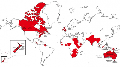
Source: Libecap, Lueck, O’Grady (2011).
The temperate colonies in North America, Australia, and New Zealand were particularly important. Abundant land in these regions offered the possibility of transplanting British farms, agricultural practices, crops, and land institutions. A key question was whether land would be divided up in a decentralized, unsystematic manner, with individual land claims and demarcation through traditional English metes and bounds, or whether it would be managed through the more coordinated, centralized, systematic survey of land parcels into squares prior to distribution and occupation.
The answer was mixed across the colonies, and the process illustrates when and how economically beneficial institutions can be disseminated. Ultimately, three demarcation systems emerged: traditional decentralized metes and bounds, centralized rectangular survey, and a mixed pattern that was centrally-controlled but had more variable parcel shapes.
In our analysis, the key determinants of a British colonial demarcation system were i) Time of settlement—very early colonies were more likely to adopt metes and bounds, in part because of the absence of effective survey technologies; ii) Terrain—squares were more apt to be implemented in flat areas where their productivity benefits were greatest, whereas the mixed system or the metes and bounds system was more likely to be used in more rugged regions where shape flexibility was needed; and iii) Strong colonial control—coordinated demarcation in squares required control over the settlement process. In places where colonial governments were weak, settlers migrated and claimed lands independently so that coordinated, clear boundaries and centralized addressing made possible by a broad rectangular system was not feasible.
Some land demarcation practices are more effective than others.
We find that metes and bounds demarcation was used in the Southern American Colonies, the Middle Atlantic Colonies, New South Wales, Tasmania, Queensland, and Western Australia—relatively early colonies, often with rugged terrain and with little control over the internal migration of land claimants. Rectangular systems were used in the (U.S.) Federal Public Lands, the Canadian Dominion Lands (west of Ontario), Ontario, New Brunswick, South Australia, and Victoria. These areas were settled comparatively later, were typically flatter, and officials here had more effective control over internal migration. For example, South Australia was the definitive planned colony. Colonized by the South Australian Land Company, its flat terrain was surveyed into rectangular grids with a new land registry system designed to facilitate the clear assignment of land rights and active land markets. Internal migration was strictly controlled by the Company.
Mixed demarcation systems were implemented in New England, Nova Scotia, Quebec, and New Zealand. Although all of these colonies were early, except New Zealand, there was greater control over settlement and land rights demarcation, and the topography often was rough. Many of the colonies were communal, allowing for coordination in demarcation, such as occurred in the New England townships. In New Zealand, settlement restrictions were implemented by the New Zealand Land Company. Survey improvements by the mid-nineteenth century allowed for large-scale surveys even in the rough areas found on the North and South Islands. While squares were not used, a centralized demarcation system provided specified land location, addresses, and well-defined parcel boundaries. Figure 2 provides examples of the differing types of land demarcation practices found across the British Empire.
Figure 2: Land demarcation practices in the British colonies
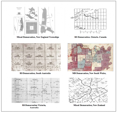
Source: Libecap, Lueck, and O’Grady (2011).
What does all of this mean for economic growth today? There are persistent differences in economic growth across the countries of the world, but many of the most successful ones are former members of the British Empire. This is no coincidence. At the time that England was establishing its empire across the globe, it was the most successful economy in the world and the greatest military power. The institutions underlying economic growth—secure property rights, rule of law, contract enforcement, active markets—were in place in Britain. The colonies offered a laboratory for further improvements, especially in terms of the demarcation of land rights.
As our research reveals, however, even under these circumstances, the process was not a smooth one. In some colonies, despite the efforts of colonial administrators, the old metes and bounds system prevailed. In others, however, the rectangular system or squares—preferred by the Colonial Office—was put into place. Finally, a third, mixed demarcation method, useful in more rugged terrain, developed.
Several conclusions can be drawn from this historical experience. One is that there are advantages to having been a British colony because of the beneficial institutions that could be transplanted from England. Second, the transplanting of institutions requires some centralized control, but at the same time, flexibility to local conditions. Third, to this day, the effects of those institutions persist. Once in place, they have long-lasting implications for the countries’ patterns and levels of economic growth. Fortunately for the inhabitants of most of the former British Empire, even those in tropical countries, institutions that promoted growth were adopted, in some cases over 200 years ago, and their advantages remain.